Las Burras
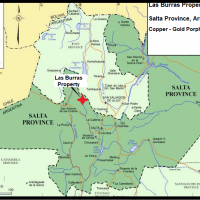
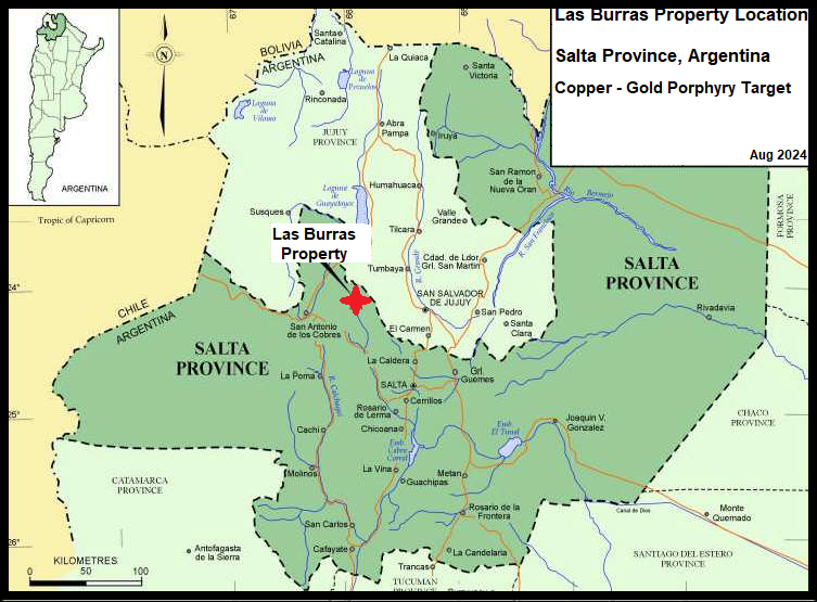
Las Burras Property, Salta Province, Argentina
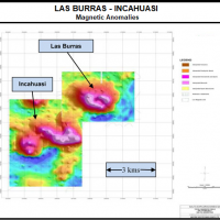
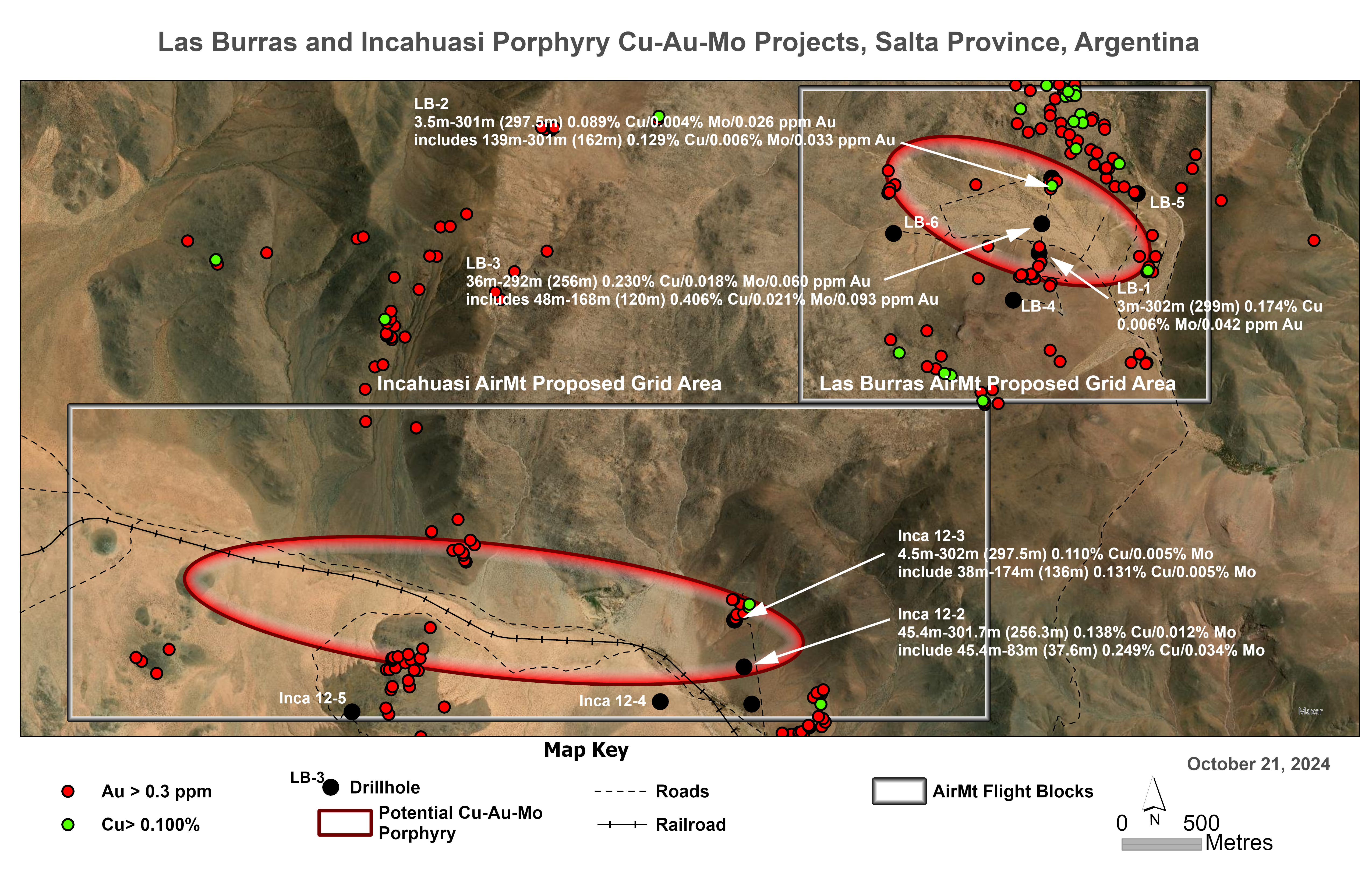
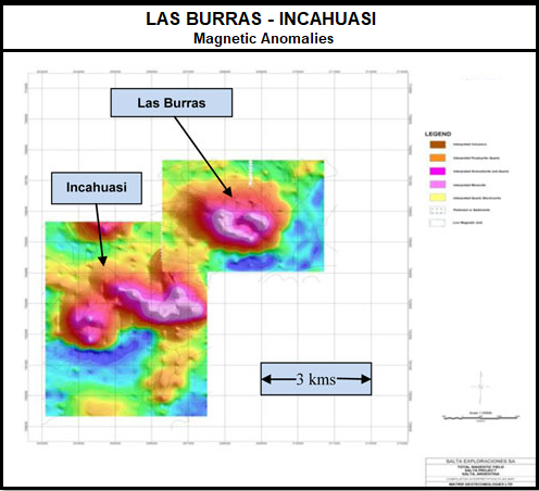
Although the 56.8 square kilometre property hosts two separate porphyry systems, at this time Orestone will focus will be on the Las Burras porphyry system.
Las Burras Copper Gold Porphyry
Las Burras is a porphyry copper hosted in Miocene granitic rocks intruded into Cambrian granitic rocks and hornfels sediments of the Late Proterozoic Puncoviscana Group. Mineralization occurs as a 800 metre x 1000 metre zone of intense quartz sericite pyrite stockwork overprinting potassic biotite alteration. A leached cap assemblage of jarosite, goethite and live hematite with secondary copper as chrysocolla and turquoise is exposed on surface grading laterally into argillized rocks. Swarms of ENE and WNW trending auriferous quartz sericite tourmaline sulphide veins occur peripheral to the porphyry.
Las Burras is hosted primarily within a porphyritic quartz monzonite - monzodiorite at the north end of a thirty square kilometer stock of calc-alkalic composition north of the El Toro lineament. The El Toro liniment extends west for 320 kilometres to the giant Escondida Copper Mine and controls other mineralization within the belt such as the Taca Taca Copper Gold Molybdenum Deposit of First Quantum Minerals, located 200 kilometres to the west of Las Burras. A major northwest trending transverse fault zone with sinistral movement is located 25 kilometres to the south. A conjugate system of WNW and ENE dextral faults at Burras has controlled the emplacement of the copper-gold mineralization.
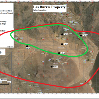
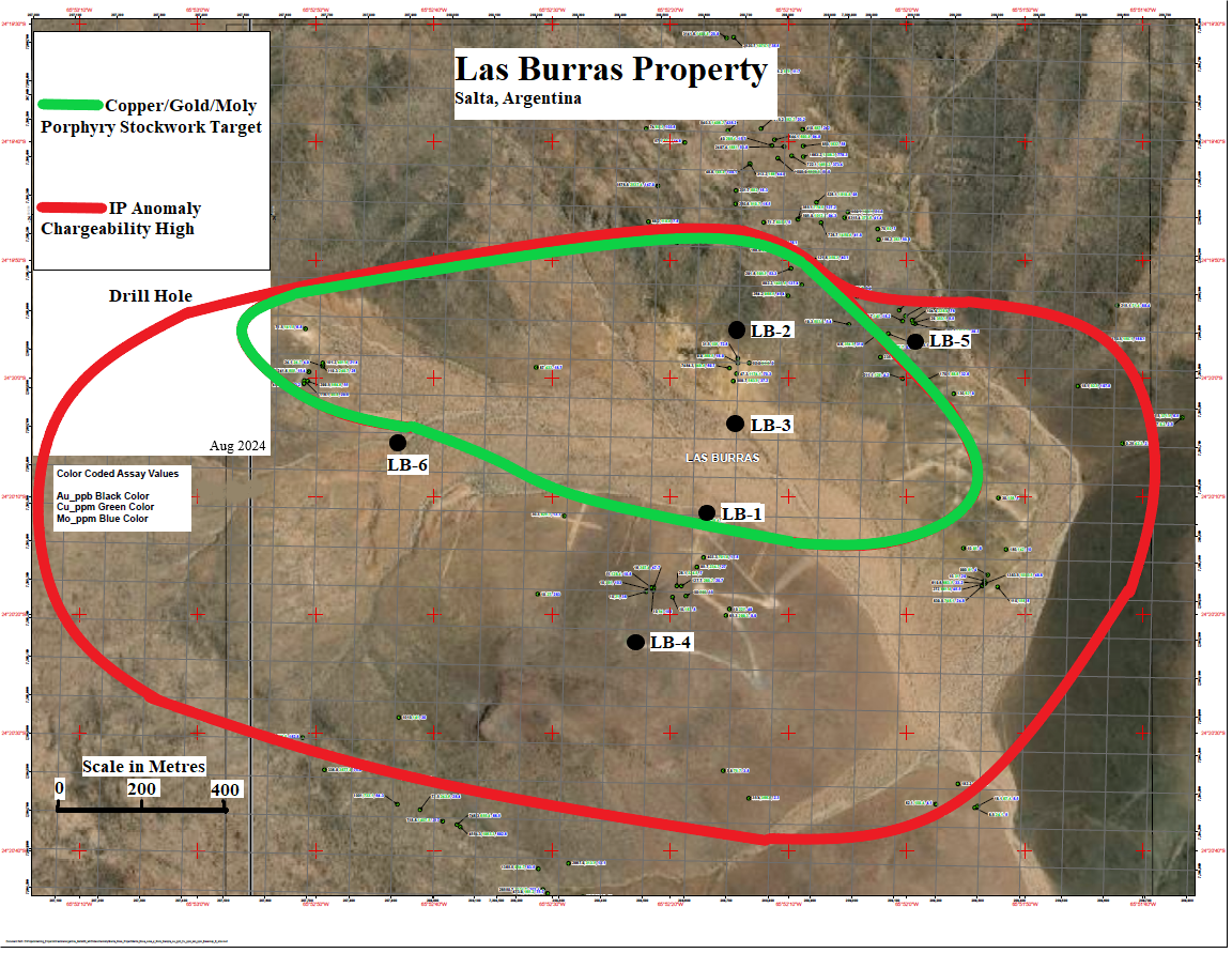
A ground IP-Resistivity and magnetic survey over a 4000 x 5000 metre area has outlined a strong IP chargeability anomaly over a strike of 3000 metres and width of 1500 metres (conductivity high-resistivity low). The IP-conductivity high is also coincident with a magnetic low indicating hydrothermal magnetic destructive alteration.
The Las Burras copper gold porphyry was discovered in 1997 by Mansfield Minerals and explored from 1997-1998 in a JV with Teck Corp. A $400,000 exploration program consisting of geological mapping, rock sampling, trenching and an IP-Resistivity survey outlined the copper-gold porphyry system however, no drilling was done and the property was dropped in 2001.
Cascadero Copper acquired the property by staking in 2005 and carried out several exploration programs of rock sampling, IP-Resistivity and magnetic surveys in the period 2005-2010 and drilled 6 diamond drill holes totaling 1665.7 metres were completed.
The drilling intersected strong copper-gold mineralization in three drill holes spaced at 250 metre centers within the mapped 1000m x 800 zone of intensely sericite-pyrite altered and vein stock worked monzodiorite intrusive. Mineralization within these holes in an alluvium covered valley consists of strong sericite-pyrite alteration overprinting potassic alteration. This suggests that a mineralized potassic core is at greater depth or laterally to LB-3 in the centre of the valley.
Drill hole LB-3 intersected 256 metres grading 0.23% copper, 0.06 ppm gold and 0.019% molybdenum beneath alluvial cover from 36 metres including a 112 metre section from 48-160 metres grading 0.42% copper, 0.097 ppm gold and 0.020% molybdenum. Mineralization remains open to depth.
Drill hole LB-1, located 250 metres south of LB-3 intersected 296 metres grading 0.18% copper, 0.042 ppm gold and 0.006% molybdenum from 4-300 metres with mineralization open to depth.
Drill hole LB-2 drilled 250 metres north of LB-3 near the margin of the IP anomaly intersected 298 metres from 3-301 metres grading 0.09% copper, 0.026 ppm gold and 0.004% molybdenum, including 160 metres grading 0.13% copper, 0.033 ppm gold and 0.006% molybdenum with mineralization open to depth.
These holes indicate a large robust copper-gold-molybdenum porphyry system only partially tested by drilling.
During 2024/2025 Orestone plans to complete an Airborne MagnetoTellurics (AirMt) survey over the mineralized target to better outline the conductive porphyry system to depth and drill test the areas beneath, west of and east of drill hole LB-3 along a 1500-2000 metre x 400-750 metre trend where there has been no drilling.